
![]()
|
|
|
Table of Contents
Africa is a large continent and is traditionally divided into two regions: Sub-Saharan Africa (the area below the Sahara) and North Africa. The latter is normally grouped in a region with Southwest Asia because North Africa and Southwest Asia have a great deal of culture, history, economics, politics and geography in common. The narrow transition zone between Sub-Saharan Africa and North Africa shares characteristics of both ... as is common with transition zones. The African Transition Zone cuts across Sudan and extends through the widest part of the African continent. The African Transition Zone creates a boundary for the realms of North Africa and Southwest Asia dividing the Islamic influence to the north from the Christian influence to the south. It is also a transitional boundary between the dry and arid type B climates and the more tropical type A climates of Equatorial Africa.
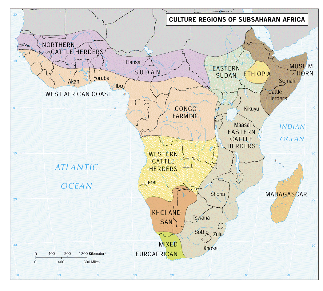
Sub-Saharan Africa
Major Geographic Qualities1. plateau continent that is physiographically unique 2. comprised of dozens of nations and hundreds of ethnic groups 3. realm of subsistence farmers 4. inefficient state boundaries represent colonial legacies 5. dislocated peoples and refugees 6. raw materials and resource potential 7. The True Size of Africa -- stunning map!
Physical Characteristics1. no linear mountain backbone: Africa has few mountains. Most mountains in Sub-Saharan Africa are found in the eastern highlands.
2. rift valleys: large depression in the earth’s surface formed by shifting tectonic plates … The Great Rift Valley stretches from the Jordan River in Southwest Asia to the Zambezi River in Mozambique, slashing a Y-shaped trench more than 3,500 miles long with escarpments a mile high.
3. rivers and lakes: Water Systems influenced by landforms shaped millions of years ago. Cuts in Great Rift Valley form Africa’s largest lakes. Long rivers are due to plateaus. High escarpments create rapids and waterfalls, block easy inland travel by river. Four great rivers slice through Africa – Nile, Congo, Niger and Zambezi. Rivers and waterfalls create incredible potential for hydroelectric power, economic development.
4. plateau continent: Plateaus make up most of Africa. Narrow coastal plains extend inland less than 20 miles – edge the continent. Sudden rise prevented easy access to interior of Africa. Separating plateaus are steep cliffs or slopes known as escarpments. Broadest plateaus and steepest escarpments are found in south and east. Rivers spill over escarpments in thundering waterfalls known as cataracts, as they plunge toward the Atlantic or Indian Oceans. Africa has the highest overall elevation of any other continent. Average elevation south of the Sahara is 2,000 feet above sea level.
5. natural resources: diamonds in South Africa, ½ of world’s gold from Great Rift Valley and South Africa, Central Africa is rich in copper, hydroelectric power growing, solar power beginning to develop, oil in Nigeria, Angola, Gabon and Congo
6. drought and desertification: Drought has always been an issue in this part of the world, but as populations continue to rise and the need for food production increases, the specter of prolonged drought becomes an even greater threat. In places such as East Africa, food shortages caused by drought have been further compounded by civil strife. Another concern associated with drought is desertification. (See map to right.) While meteorological conditions may limit rainfall, desertification can be accelerated by human activities such as improper cultivation and overgrazing, which can lead to the loss of soil. These habits will have to be altered in the future if the rate of desertification is to be slowed. Meanwhile, continuous monitoring of weather patterns and drought conditions helps to establish patterns and create a basis for predicting times of limited precipitation, allowing farmers and governments to plan ahead.
7. deforestation: Dependence on trees for fuel places strains on forests and wooded savannas throughout the region. The island nation of Madagascar provides a good example of the effects of large-scale deforestation on the environment. Large-scale deforestation along Madagascar's eastern coast threatens many of the unique species found on the island, including lemurs.
8. Africa's water towers: African mountains harbor the continent's most fertile soils, allowing high yield agriculture to thrive and contributing significantly to food security in the region. Millions of farmers are employed in the production of globally consumed cash crops like coffee and tea, and population density in and around mountains in Sub-Saharan Africa is high and on the rise.
In a continent dominated by arid and semi-arid areas, African mountains function as water towers for millions of people. Low-lying arid areas in countries such as Sudan and Namibia receive water from large rivers with mountain sources, while in East Africa, Mount Kenya is the only source of freshwater for more than seven million people. African mountains house many ecosystems such as forests, grasslands, drylands, rivers and wetlands, and are home to unique biodiversity including the critically endangered mountain gorillas of Central Africa and Uganda. Currently, global warming, high population growth and intensive land-use threaten Africa’s mountain areas.
Cultural Characteristics
|
|
d. Burkina Faso f. Republic of Cabo Verde (or Cape Verde) k. Democratic Republic of the Congo (DRC) l. Republic of the Congo (Brazzaville) m. Republic of Côte d'Ivoire (or Ivory Coast) o. Republic of Equatorial Guinea |
ab. Republic of Mali ac. Islamic Republic of Mauritania ae. Overseas Department of Mayotte (France) ai. Federal Republic of Nigeria ak. Saint Helena, Ascension and Tristan da Cunha (UK) al. Democratic Republic of São Tomé and Principe ap. Federal Republic of Somalia ar. Kingdom of Eswatini (formerly Swaziland) |
Political Resources on the Net
Google's Arts & Culture collection virtual world museum tours
 Sir
Samuel Baker was a 19th century
British explorer and naturalist who traveled extensively throughout Africa,
often with his wife Florence. He was instrumental in early explorations along
the Nile and made several expeditions into Central Africa. Baker is credited as
the first European to see Lake Albert, a huge body of water in Uganda. Seeing
the impact of the slave trade on the people of Africa, he was also an outspoken
advocate of abolishing slavery before the idea was popular opinion.
Sir
Samuel Baker was a 19th century
British explorer and naturalist who traveled extensively throughout Africa,
often with his wife Florence. He was instrumental in early explorations along
the Nile and made several expeditions into Central Africa. Baker is credited as
the first European to see Lake Albert, a huge body of water in Uganda. Seeing
the impact of the slave trade on the people of Africa, he was also an outspoken
advocate of abolishing slavery before the idea was popular opinion.
Angola | Economy | Miradouro da Lua | Luanda | Deadliest Country for Kids | Angola bans Islam and shuts down all mosques across the country because it 'clashes with state religion of Christianity.' | Freedom House: Angola | Photos | Daddy's Girl: How an African 'Princess' banked $3 billion in a country living on $2 a day
Benin |
Porto-Novo (4:36)
|
Cotonou (9:53)
|
Dahomey kingdom
|
Most Haitians trace their ancestry to Benin.
|
Culture |
SELF |
Photos |
Royal Palaces of Abomey (See also
the Gallery and Video tabs.) |
The Real Warriors Behind The Woman King
|
The Real Warriors Behind The Woman King
Botswana | Government | World Bank: Botswana | Culture | A hunting ban saps a village’s livelihood | A wetland oasis amid desert lands | African Wildlife Foundation: Botswana | Okavango Delta | Botswana Cam
Burkina Faso | Burkina Faso a 'model of religious tolerance' | Mossi kingdom | Songhai kingdom | Ouagadougou | Burkina Faso: Testing the Tradition of Circular Migration | Literacy: Burkina Faso | Military Officers Announce Coup in Burkina Faso (09/30/22)
Burundi | Hutu | Tutsi | The heart of the Hutu-Tutsi conflict | Political unrest leaves Burundi facing food shortage | Burundi killings could ignite wider African crisis, UN report warns | Human Rights Watch: Burundi | The world looks away as blood flows in Burundi
Cabo Verde | The islands | Democratic government | Emigration: Cabo Verde | African and Portuguese antecedents | Economy | A Semana (news)
Cameroon | Development: Cameroon | The Elephants of Cameroon (Loxodonta africana) joined the endangered species list in 1988. Concern for their survival arose after increasing ivory prices provoked unprecedented poaching during the 1970s. In little more than a decade, poachers killed more than half of Africa's elephants. This site is about a conservation program designed to help preserve this important species in Africa. | 100,000 Elephants Killed by Poachers in Just Three Years | Explore court life in a Cameroon Grasslands kingdom.

Central African Republic | Muslim and Christian militias | Séléka Muslims | Christian anti-Balaka (anti-machete) militia | The African Union and CAR (See also excellent list of links at end of article.) | The UN and CAR | Children Face ‘Staggeringly High’ Hunger in Conflict-Hit Central African Republic | What’s next for the Central African Republic? | Putin wants fealty, and he’s found it in Africa.
Chad | Berbers | Rabih al-Zubayr | Chad and Libya | The Aozou Strip | Oil revenues | Corruption | Chad and the World Bank | Chad and Sudan | Feuding and corruption drain Chad of its best chance
Comoros | Photos | The islands | Ecology | Strategic position | Multicultural | Domoni (7:09) | Mayotte | Radio Domoni Inter
Democratic Republic of the Congo | Democratic Republic of Congo at a Precipice | Henry M. Stanley (American correspondent) | King Leopold II (Belgium) | Joseph-Desiré Mobutu (Mobuto Sese Seko) | Cursed by its natural wealth | The 6 Fastest Growing Economies in Africa | Lubanga Case Establishes Child Soldiers as an International Crime | A Looming Calamity in the Democratic Republic of Congo | Kinshasa
Republic of the Congo (Brazzaville) | Brazzaville | Denis Sassou-Nguesso | African presidents' dilemma: Should I stay or should I go? | Stolen Asset Recovery Initiative | Ninja rebels | Republic of the Congo and France | Rain Forest and Climate Protection in the Congo Basin (7:07)

Côte d'Ivoire (Ivory Coast) | Gulf of Guinea | Yamoussoukro | Economy is one of the most developed in sub-Saharan Africa. | More than sixty distinct tribes | North vs. South | Ivoirité | I don't know about… | Laurent Gbagbo and the International Criminal Court | In Ivory Coast, lêkê are the preferred footwear.
Djibouti | Djibouti–Addis Ababa railway | Afars | The Afar: The toughest people on earth? | Somali Issas | Port of Djibouti | Djibouti and refugees | China to set up 1st overseas naval base in Djibouti next to US airbase | Why China and Saudi Arabia are building bases in Djibouti
Equatorial Guinea
|
Geography |
Bakola / Bagyeli Pygmies
|
Francisco Macías Nguema
|
Prosperity in Equatorial Guinea |
New oil prosperity benefits only Macao.
|
Corruption and mismanagement
|
Malabo |
World’s longest-ruling dictator to extend his 43 years in power
|
World’s longest-ruling dictator to extend his 43 years in power
Eritrea | Geography | Aksum | Ethiopian province | Fight for independence lasted 32 years. | Exodus from Eritrea after independence dream became a nightmare. | Asmara
Ethiopia is located in East Africa. It is the second most populated nation on the African continent after Nigeria. Since 1993, Ethiopia has been a landlocked country due to the separation of Eritrea. Ethiopia is situated in an equatorial and subequatorial region, but thanks to its terrain Ethiopia has a more moderate and humid climate than its neighbors. There is a significant amount of rainfall; rivers flow; there is no shortage of water for irrigation. It is also the most mountainous country in Africa. Mountains occupy about half of its territory, the rest is plains - the Ogaden plateau in the southeast, the Afar Depression in the northeast and the lowland of the Baro River basin in the far west. Erta-Ale is the most active volcano in Ethiopia. It is an integral part of the so-called Afar Triangle, a zone of intense volcanic activity. Its name translates as "Smoking Mountain," which is not surprising because Erta-Ale is one of the five volcanoes in the world that has a lava lake in the crater. The patterns of fire strips and the lava level are continuously changing; the superfluous lava unceasingly flows from the crater and sometimes creates a unique second lava lake (there are no similar examples among volcanoes). The Ethiopian volcano, Dallol, is known as "the hottest place on Earth." The volcano itself is a crater filled with yellow-green-brown-red lakes containing acid or lye, which bubble and evaporate into sulfurous vapors. | Ethiopia | History and Legend in Ethiopia | The 6 Fastest Growing Economies in Africa | Sacred Sites of Ethiopia | The Hottest Inhabited Place on Earth | Wolves of Ethiopia
Gabon | Geography | El Hadj Omar Bongo Ondimba | Economy | This African country is taking an unprecedented step in internet censorship | Bongo family corruption investigation | Gabon Corruption Report
The Gambia | Geography | Slavery was the chief source of revenue. | History | Economy | Censorship of the press: The Gambia | Freedom Newspaper | Gambia’s Yahya Jammeh, a dictator and ‘proud’ of it | Gambia moves toward overturning landmark ban on female genital cutting.
Ghana | History and Geography | Government | Ghana Web | Ghana's performance in economic freedom improves | Ghana football | Ghana radio | Crisis and Bailout: The Tortuous Cycle Stalking Nations in Debt
Guinea |
Geography |
Culture |
Mount Nimba Strict Nature Reserve |
Economy |
Guinea and refugees
|
Ebola
Guinea-Bissau | Kingdom of Gabú | Bolama Photos (Bolama is an administrative region in Guinea-Bissau, consisting primarily of the Bijagós Archipelago off the country's southern coast.) | Crony capitalism | World Bank: Guinea-Bissau | Transparency International: Guinea-Bissau | Guinea-Bissau, After Coup, Is Drug-Trafficking Haven. | Economic Community of West African States imposes sanctions on Guinea-Bissau junta leaders. | EU pull-out hits Guinea-Bissau reforms.
Kenya | Riding the matatu in Nairobi Kenya (1:53) | The upside to lions in the backyard | Meet the Maasai of East Africa, one of 40 officially recognized tribes in Kenya, East Africa. | Listen to the morning animal chorus in the Maasai Mara Reserve, Kenya. (18:49)
Nairobi, Kenya is a medley of different quarters, varying from wealthy suburbs, which were home to European colonists long ago, to slum areas. One of these districts, Kibera, is famous for being the largest slum area in Africa. According to different sources, the number of inhabitants of this district varies from 200,000 to one million people.
Lesotho | Geography and Economy | Sehlabathebe National Park | Lesotho Highlands Water Project | Emigration and remittances (Executive Summary, pages 1-3) | HIV and AIDS | Sacred Sites of Lesotho
Liberia | Founding of Liberia | Civil war | Who’s who? | Reporter's slideshow | Liberian women act to end civil war, 2003. | This is what Liberia looks like 10 years after a devastating civil war. | Liberia Tops UNICEF ranking of 10 worst countries for access to primary school. | Liberia: From warzone to holiday paradise?
Madagascar | Welcome to Madagascar | Madagascar's labyrinth of stone | A relic of days past in Madagascar (1:46) | An ancient island's greatest secret | National Geographic: Madagascar | Photos
Malawi | Official government site | Geography | Poverty, drought and felled trees imperil Malawi water supply. | Sacred Sites of Malawi | Nyasa Times | Confronting a sexual rite of passage in Malawi | HIV and AIDS: Malawi | Take a virtual tour through Malawi

Mali | Geography | Culture | Timbuktu | Sacred Sites of Mali | Islamist insurgency | Mali leader warns UN: Qaeda, Islamic State gaining ground in country. | Djenne mosque | Freedom of the press: Mali
Mauritania | Millions of youths in Africa's Sahel could be recruited by terrorist groups, UN envoy warns. | Geography | Slavery’s last stronghold | Eye of the drought: high and dry in the Sahara – in pictures | Child marriage in Mauritania: 'When it has ended, I will be so happy' (2:59) | 'The best solution? Move the Mauritanian capital': water on the rise in Nouakchott | Forced to Be Fat | National Democratic Institute: Mauritania
The island of Mauritius owes its existence in the midst of the Indian Ocean to volcanic activity. Since then erosion has flattened the surface of its territory. Present-day Mauritius includes plateaus and mountains, the highest one 2,710 feet tall. One of the most famous and unusual features of Mauritius are the sand dunes of seven distinct colors: red, brown, violet, green, blue, purple and yellow. These sands settled spontaneously in different layers creating the unusual landscape. In spite of torrential tropical rains, the dunes never erode. The plains and mountains of Mauritius are cut with a multitude of small rivers with rapids and waterfalls. | The Underwater Waterfall: One of the most beautiful places on earth (01:09)
Mauritius | Geography | Photos | Mauritius: The best Africa destination you know almost nothing about | Economy | What Mauritius can teach us about the global arms trade | In Mauritius, gourmet rice points to a brighter future. | Forbes best countries for business: Mauritius
Mozambique | The 6 Fastest Growing Economies in Africa | Mozambique: Armed forces must not 'Abandon the dream.' | Mozambique is still tense after riots. (1:35) | After 22 years of work, Mozambique is free of land mine peril. | Mozambique faces race against time to end illegal logging. | No vacancies: life in Mozambique's abandoned Grande Hotel – in pictures | World Bank: Mozambique | Mozambique’s New National Park
Namibia,
located in southern Africa, has some of earth’s most unique geography. The main
part of the country is occupied by highlands. The Central Plateau is situated
 between the Namib Desert, which looks toward the Atlantic Ocean and the Kalahari
Desert; in the South it is bounded by the Orange River while the north is
covered with jungles.
Sossusvlei (dead-end marsh) is possibly Namibia’s
best-known area. Characterized by the large red dunes that surround it,
Sossusvlei is a large, white, salt and clay pan. The
dunes in this area
are some
of the highest in the world, reaching almost 1,300 feet. Their color can vary
from apricot and orange to deep red and maroon, creating a dazzling contrast to
the salt hollows lying at their bottom. Strong winds blowing from different
directions create
fantastic forms of the dunes. During the short wet season,
which usually occurs in February, the plateau fills with water from the Tsauchab
River. Sossusvlei is the place where the dunes come together preventing the
Tsauchab River
from flowing any further, some 37 miles east of the Atlantic
Ocean. Deadvlei (dead marsh) is another clay pan, a little more than 1 mile from Sossusvlei.
Deadvlei used to be an oasis with several acacia trees. Then the
river that watered the oasis changed its course. The pan is thus punctuated by
blackened, dead acacia trees, in vivid contrast to the shiny white of the salty
floor of the pan and the intense orange of the dunes. This creates a
particularly fascinating and surrealistic landscape that appears in innumerable
pictures and has been used as a setting for films and videos. The Namib Desert
has one more interesting locality bearing a rather sinister name – the
Skeleton
Coast. It is one of the most ancient layers of the
earth’s surface
and consists
of a massif of solid rock estimated to be one and a half million years old.
Fog, huge boulders, storms and the cold ocean currents near the Cape of Good
Hope create hazards for shipping. Lots of shipwreck remnants can still be found
here. |
Namibia |
Sacred Sites of Namibia |
Photo Gallery |
A Mystery in the World’s Oldest Desert |
See the stretch of coastline in Namibia that’s
often referred to as
the end of the Earth.
between the Namib Desert, which looks toward the Atlantic Ocean and the Kalahari
Desert; in the South it is bounded by the Orange River while the north is
covered with jungles.
Sossusvlei (dead-end marsh) is possibly Namibia’s
best-known area. Characterized by the large red dunes that surround it,
Sossusvlei is a large, white, salt and clay pan. The
dunes in this area
are some
of the highest in the world, reaching almost 1,300 feet. Their color can vary
from apricot and orange to deep red and maroon, creating a dazzling contrast to
the salt hollows lying at their bottom. Strong winds blowing from different
directions create
fantastic forms of the dunes. During the short wet season,
which usually occurs in February, the plateau fills with water from the Tsauchab
River. Sossusvlei is the place where the dunes come together preventing the
Tsauchab River
from flowing any further, some 37 miles east of the Atlantic
Ocean. Deadvlei (dead marsh) is another clay pan, a little more than 1 mile from Sossusvlei.
Deadvlei used to be an oasis with several acacia trees. Then the
river that watered the oasis changed its course. The pan is thus punctuated by
blackened, dead acacia trees, in vivid contrast to the shiny white of the salty
floor of the pan and the intense orange of the dunes. This creates a
particularly fascinating and surrealistic landscape that appears in innumerable
pictures and has been used as a setting for films and videos. The Namib Desert
has one more interesting locality bearing a rather sinister name – the
Skeleton
Coast. It is one of the most ancient layers of the
earth’s surface
and consists
of a massif of solid rock estimated to be one and a half million years old.
Fog, huge boulders, storms and the cold ocean currents near the Cape of Good
Hope create hazards for shipping. Lots of shipwreck remnants can still be found
here. |
Namibia |
Sacred Sites of Namibia |
Photo Gallery |
A Mystery in the World’s Oldest Desert |
See the stretch of coastline in Namibia that’s
often referred to as
the end of the Earth.
Niger | Geography | Our Africa: Niger | Culture | Child bride marriage in Niger | Niger protesters set churches on fire. | Amnesty International: Niger | Niger: Giraffes make an impressive comeback in Niger | African Wildlife Foundation: Niger | World Heritage Sites: Niger | Lost Tribes of the Green Sahara
Nigeria | Government | NigeriaWorld | Nigeria culture and heritage | Development: Nigeria | Boko Haram violence leaves families 'teetering on edge of famine' - aid groups. | Central Africa launches regional war against Boko Haram. | Why people join Nigeria’s Boko Haram | Human Rights Watch: Nigeria | The Authority | Nigeria’s Creaky Political System | Will Nigeria's booming population lead it to prosperity or poverty? | Read Your Way Through Lagos: A Megacity of Extremes
Rwanda |
Geography |
Government |
The Rwandan Genocide (If you haven’t already seen it, watch
Hotel Rwanda. The movie doesn’t come close to the true horror of what
happened but it’s close enough.)
|
How to Recover From Genocide? What Iraq Can Learn From Rwanda
|
My journey back to Rwanda: confronting the ghosts of the genocide 21 years later
|
The 6 Fastest Growing Economies in Africa |
No power or running water – but digital books galore
|
The boring infrastructure that Rwanda needs
|
Rwandan president condemns US 'disappointment' as he seeks third term.
|
Human Rights Watch: Rwanda
Saint Helena, Ascension and Tristan da Cunha (British overseas territory in the South Atlantic Ocean, midway between Africa and South America) | Geography | Government | St. Helena | Ascension | Tristan da Cunha | The Island Ready to Welcome the World | Longwood House: Napoleon’s home in exile, decorated with poisonous wallpaper. | Life on one of the world's most remote islands | Britain doubles ocean protection around overseas territories. | Islanders 'happy to stay cut off.' | Island 'at risk without airport.' | Photos
São Tomé and Principe | Geography | Economy | World Bank: São Tomé and Principe | The chocolate islands | Culture | Photos | São Tomé and Príncipe Biodiversity Project | Photos 2 | São Tomé: Before it’s gone (4:31)
Senegal | Geography | Culture | Our Africa: Senegal | Sacred Sites of Senegal | OPIC commits to Senegal’s wind farm project. | Young men in Senegal join migrant wave despite growing prosperity at home. | Senegal: New steps to protect talibés, street children | Senegal’s former president defends aged leaders: 'My father worked until 105.' | On the Streets of Dakar | Africa’s youngest president takes office, promising ‘systemic change.’
Seychelles | Government | Commonwealth: Seychelles | Seychelles: A successful socialist country, with terrible PR | Geography | Inner islands | Outer islands | Vallée de Mai | Aldabra | Seychelles sinks as climate change advances. | Global Edge: Seychelles | How the island of Seychelles became a haven for dirty money.
Sierra Leone | Founding of Sierra Leone | Photos | Mass graves beckon for Sierra Leone's homeless and destitute dead. | Sierra Leone resumes long battle to save mothers and children – in pictures. | Garbage takes over Portee Junction. | Sierra Leone girls forced into 'degrading' pregnancy tests after school ban. | Blood Diamonds: The conflict in Sierra Leone | Cheap, plentiful and devastating: The synthetic drug kush is walloping Sierra Leone. | Risking a society’s retribution, growing numbers of girls resist genital cutting.
Somalia | Culture | Facts and Photos | Somalia readying for extraordinary electoral process. | International Rescue Committee: Somalia | Somali refugee Fadumo Dayib runs for president 26 years after fleeing civil war. | UN plan sends thousands of refugees back into a war zone in Somalia. | Somalia: one man’s terrorist is another man’s carpenter. | Somali government pledges to fight FGM at first national forum. | Pirates of Puntland, Somalia | Recognition for Iraqi Kurdistan and Somaliland
Cape Town, South Africa, is one of the most popular cities on the African continent. It is located in the southwestern part of the continent, on the shore of the Atlantic Ocean, near the Cape of Good Hope. The first settlements in this area date back to over 12 000 years. There is a large colony of African penguins (5:29) right next to Cape Town. These penguins live near the coast, which is washed by a cold Benguela current. Seals rest right on the city piers next to the speed boats and restaurants. However, the main attraction of Cape Town is the famous Table Mountain, featured on South Africa’s flag. This mountain was the first one to greet seafarers arriving at this part of the African continent. Back in those days, captains even offered a golden coin to a sailor who was the first one to see the long-awaited sign of the land ahead. This natural plateau raises over 3,200 feet over sea level and literally hangs over Cape Town, creating a lively background and a pleasant climate. | South Africa | Sacred Sites of South Africa | Young South Africans face one of the highest youth unemployment rates in the world. (11/2023)

The Drakensberg (Dragon Mountains) is situated on the territory of three countries: South Africa, Eswatini and Lesotho. The latter one deserves a special mention — it is a unique enclave within the Republic of South Africa, and it's surrounded by the Drakensberg Mountains in the east and south. The Drakensberg is a beautiful mountain range cut by numerous rivers. You can also see Tugela Falls that drops in five free-leaping falls from the eastern cliff. The highest of them (1,348 feet) drops water with an average speed of 35 cubic feet per second. The total drop in five free-leaping falls is 3,110 feet, which makes Tugela Falls the second highest waterfall in the world after Angel Falls in Venezuela. Tugela sometimes freezes and forms dazzling ice columns. Over the waterfalls you can see the Mont-aux-Sources Mountain, the source of Tugela River and considered one of the biggest in South Africa. They say that these lands inspired Tolkien, who was born in South Africa, to write his epic Lord of the Rings novels. The Drakensberg is not like any other mountain range in the world. Here one can find peaks next to completely flat tops, and rainforests next to meadows and savannas. Historically, this area was inhabited by the Bushmen (a collective name for indigenous African tribes). Little is known about the Bushmen of the Drakensberg. The last group was seen in 1878 and then they disappeared, leaving behind the only reminder of their existence — amazing rock paintings. The paintings are unique not only because of their good condition, but also because of the variety of subjects: hunting scenes, religious ceremonies and peaceful life depictions reveal every detail from the history of these mysterious ancient people. The Drakensberg is rich in various minerals: coal, manganese ores, tin ores, gold and even platinum. Finally, nothing can compare to the Drakensberg's flora and fauna. Of 2,153 plants, 119 are listed as endangered and 98 are endemic, which means that they can't be found anywhere outside these places. It is a home to 299 bird species; and among the unique animals there are the endangered white rhino and white-tailed gnu.
There are three notable deserts in Africa: the Namib, the Sahara and the Kalahari. See the Kalahari from the perspective of a !Kung woman.
Swaziland Gets a Name Change: Call It Eswatini Now | Swaziland | Government | Economy | Geography | Culture | Sacred Sites of Swaziland | Last dance for the playboy king of Swaziland? | HIV and AIDS: Swaziland | Swaziland acting as 'puppet' to South Africa in bid to legalize rhino horn trade. |Times of Swaziland
Tanzania |
Geography |
Culture |
African Studies Center: Tanzania
|
Sacred Sites of Tanzania
|
Tanzanian land rights victory earns Masaai leader Goldman prize.
|
Tanzania's floating national park
|
Serengeti Safari
|
The Clouds of Kilimanjaro
|
Blast fishing turning Tanzania's waters into 'killing fields.' |
The 6 Fastest Growing Economies in Africa
|
World Bank: Tanzania |
Listen to the evening animal chorus in the Amani Nature Forest Reserve in the
East Usambara Mountains, Tanzania. (18:49)
|
Listen to the evening animal chorus in the Amani Nature Forest Reserve in the
East Usambara Mountains, Tanzania. (18:49)
Africa lacks a large mountain range of linear character such as the Andes of South America, the Alps of Europe or the Himalayas of Asia. However, it does have some very large mountains, perhaps the most famous of which is Mount Kilimanjaro. | Mount Kilimanjaro, Tanzania Cam
Togo | Geography | Culture | Economy | Economy 2 | African Studies Center: Togo | Freedom House: Togo | Development: Togo | Voodoo New Year (2:17) | Lomé, Togo | Chasing Ivory Poachers, Smugglers in West Africa, Part I (9:15) | Black Market Ivory Investigation: Going After 'The Boss,' Part II (5:52)
Uganda | Geography | Our Africa: Uganda | Journey through the Pearl (some marvelous photos) | Uganda's endangered gorillas (4:48) | Gorillas in the mix in Uganda | Ugandan wildlife dying in national park from drought. | Uganda takes on the 'world's most dangerous road.' | Uganda: To spend $2 billion on power connections, grid | Development: Uganda | Human Rights Watch: Uganda | New Vision
Zambia |
Geography |
Livingstone’s Zambia
|
Three Rivers (2:50)
|
Witness Africa’s ‘other’ epic migration
|
African Wildlife Foundation: Zambia
|
Our Africa: Zambia
|
Economy |
A test case for democracy |
Democracy is under challenge In Zambia.
|
Zambia accused of attacking press freedom as newspaper is closed and editor
jailed. |
Africa rulings move LGBT rights forward. |
Transparency International: Zambia |
Lusaka Times |
In Search of Zambia’s Stunning Wildlife
|
In Search of Zambia’s Stunning Wildlife
Zanzibar (semi-autonomous archipelago of Tanzania) | About Zanzibar | Geography | 36 hours in Zanzibar, Tanzania | A father and son capture Zanzibar's past and present stories. | Where is Zanzibar? | 14 Things to Know Before You Go to Zanzibar
Zimbabwe | Breaking the silence | The ageing world leaders who just can't let go - in pictures | Zimbabwe may have extreme poverty, but the Mugabes just launched a new ice cream company. | Digging for the missing $15 billion of diamond revenue in Zimbabwe | The breadbasket is still a basket case. | New Zimbabwe law allows seizure of smart phones and laptops as Mugabe turns on social media. | Zimbabwe paralyzed by general strike as Mugabe runs out of money. | Great Zimbabwe | Mysteries of Great Zimbabwe | Sacred Sites of Zimbabwe | African Wildlife Foundation: Zimbabwe | The Zimbabwean
Victoria Falls,
on the Zambia and Zimbabwe border, is one of the most spectacular attractions of
Africa and one of the most unusual waterfalls in the world. The falls are
created by the Zambezi River as it suddenly plummets into a narrow, 328-foot
deep chasm. The water’s roar can be heard from 25 miles away. The spray
and mist from the falling water rises up to 1,312 feet and is visible from a
distance of 31 miles. Even the rainbows are incredible. They are of the "moon"
kind … produced by the light reflected off the surface of the moon. The falls
were discovered in 1855 by David Livingstone, the British doctor and missionary,
who named them in honor of Queen Victoria. Locals called the falls Mosi-oa-Tunya
(The Smoke Which Thunders) and were afraid to even get close to them. During the
dry season, which lasts approximately from September to December, the water
level in the Zambezi River falls and one can walk through most of the waterfall,
jumping between the streams that still run down. At all other times, Victoria
Falls roars with power.
Named after Queen Victoria in 1855, Victoria Falls | Victoria Falls 2 is one of the largest and most impressive waterfalls in the world, rivaling that of Iguazu Falls in South America. The falls, which are located on the Zambezi River, drop 360 feet over a fault zone in the African plateau.
There are lots of pictures so it may take a minute for the page to open!
![]()
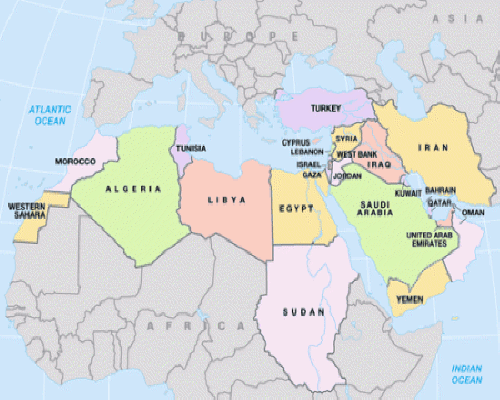

1. a crossroads region
2. Economy is prone to follow the fortunes of the oil industry.
3. Petroleum resources and location assure a global role for the region.
4. cultural hearth: a region that witnessed many cultural innovations that subsequently diffused to other parts of world
5. significant to three of the world’s religions: Judaism, Christianity and Islam
6. Has seen the rise and diffusion of Islamic fundamentalism.

1. Located at the
crossroads of three continents.
2.
Lengthy human settlement has led to environmental problems such as deforestation and overgrazing.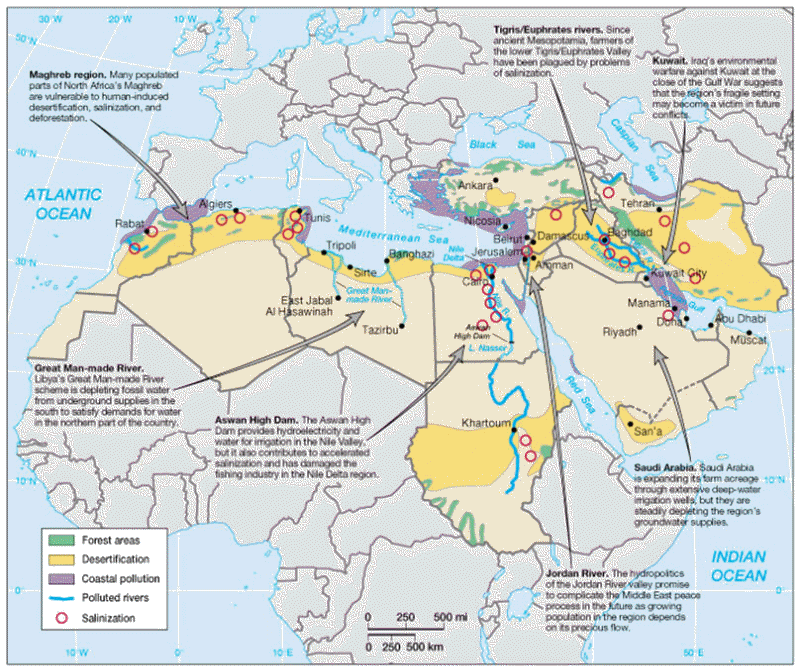
3. Salinization is the buildup of toxic salts in the soil, a side effect of irrigation, which has been used in this region for centuries. Fresh water contains small amounts of dissolved salts. Irrigation puts this water and salt on farmlands. Lack of rainfall means there’s no way to flush out the salts. Gradually salts become concentrated, ruining fields (hundreds of thousands of acres of farmland). Especially a problem in Iraq and central Iran.
4. Five basic land forms (Refer to physical map below right.)
a. Maghreb: translation from Arabic is “western island” (Morocco, Algeria, Tunisia), Atlas mountains on Mediterranean east coast are related to Alps in Europe, topography varies from mountains to sand
In pre-colonial Morocco, the imposing grandeur of the Atlas Mountains marked the boundary between the bilad el-makhzen - land under the rule of the Alaouite sultan - and the bilad el-siba, or region of anarchy. Today, to drive the circuitous route through the Atlases and into the Draa Valley is to exist on that line: It’s a transitional location where verdant gardens and soaring minarets open onto the vast barrens of the Sahara.
b.
Levant: Eastern Mediterranean region including
Lebanon, mountains within 20 miles of the
ocean, Arabian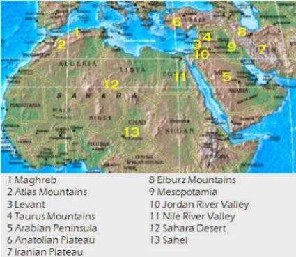 Peninsula is a plateau sloping eastward, rugged highlands in
Oman and
Yemen
with drifting dune fields elsewhere
Peninsula is a plateau sloping eastward, rugged highlands in
Oman and
Yemen
with drifting dune fields elsewhere
c. Anatolia: Iranian and Anatolian plateaus (Iran, Turkey), large peninsula of Turkey, also sometimes called Asia Minor, average height 3,000–5,000 feet, prone to earthquakes, Elburz Mountains in northern Iran are >18,000 feet
d. Mesopotamia: land between the Tigris and Euphrates rivers in modern-day Iraq
e. Jordan River Valley: straddles borderlands of Israel, Jordan, Syria and drains into Dead Sea

5. North Africa has the largest desert in the world, the Sahara, which borders the Libyan Desert and the Nubian Desert. About one-third of the Arabian Peninsula is part of the Empty Quarter of the Rub’ al Khali (Arabian Desert). This aspect of the region reveals the importance of water as a valuable natural resource. Most people in this region are more dependent on the availability of water than on the availability of oil … Sahel: area separating the Sahara from the forests of Africa, an area of temperate grassland (steppe) moving into sparse desert scrub-like vegetation.
For some cultural groups in the region, adapting to the physical environment meant migrating to cooler areas during the hottest parts of the year. Many traditionally herded livestock and migrated seasonally seeking water, grazing land and shelter. However, the way of life for many pastoral nomads in this region has changed significantly. Many governments have encouraged these groups to practice settled agriculture rather than seasonal migration, and international boundaries have often cut off traditional migratory paths.
6. Region has complex landforms and climate. Though various climate types can be found in this realm, it is the dry or arid type B climate that dominates and covers most of the physical area. Other climate types include the type H highland climate (cold temperatures at the high elevations with moderate temperatures at the bases) of the mountains of the Maghreb and Iran, and the more moderate type C climate in the coastal regions bordering the sea. The type C climate along the coastal Mediterranean area attracts human development and is home to many large port cities. The overall fact is that vast areas of the region are uninhabited desert.

1. religion
a. cultural hearth of the Judeo-Christian tradition (also ancient Egypt and Mesopotamia) … Go to North Africa and Southwest Asia, scroll a little way down the page and read the brief Cultural Hearths section (through the Nile River civilization).
b. emergence of Islam: Most people in the realm are Muslims. The practice of Islam in day-to-day life takes different forms in the various divisions of the religion. The differences between the divisions have contributed to conflict or open warfare. A major religious schism divided Islam early on and still exists. Shiites favored passing power within Muhammad’s own family. Sunnis favored passing power through established clergy and emerged victorious. (Go to Muhammad and Islam. Scroll about halfway down the page to the Five Pillars of Islam section. Read from that section through the rest of the page.) Islam acts as more than just a religion. It also serves as a strong cultural force that has historically unified or divided people. The divisive nature of the religion has often resulted in serious political confrontations within the realm between groups of different Islamic ideologies. Concurrently, the religion of Islam is also a unifying force that brings Muslims with similar beliefs together with common bonds. Islam provides structure and consistency in daily life. The faith can provide comfort and a way of living. The holy cities of Mecca and Medina are located in Saudi Arabia. Other holy cities for other divisions of Islam include Jerusalem and the two cities holy to Shia Muslims: Karbala and Najaf in Iraq. Islam dominates the realm, but other religions are significant in various regions.
c. modern Jewish state: The creation of the State of Israel in 1948 has been one of the most important political developments in this region during the 20th century and has produced an enduring zone of political tension that has often ignited into armed conflict. Searching for more secure borders and a permanent homeland for the Palestinians are but two of the critical issues facing Israel today.
d. diffusion of Islam along trade and military routes: The Islamic world created numerous sophisticated centers of culture and science with far-reaching mercantile networks, travelers, scientists, hunters, mathematicians, doctors and philosophers. It fostered cosmopolitan and eclectic Muslim cultures in the Indian subcontinent, Malaysia, Indonesia and China. Trading played an important role in the spread of Islam. Arab sailors, merchants and traders became carriers of the religion and propagated it wherever they went. The caliphs of the Arab dynasty established the first schools inside the empire which taught the Arabic language and Islamic studies. They began the ambitious project of building mosques across the empire, many of which remain today. As military conquerors, conversion by force, while not unknown in Muslim countries, was, in fact, rare. Muslim conquerors ordinarily wished to dominate rather than convert, and most conversions to Islam were voluntary. The objective of conquests was more than anything of a practical nature, as fertile land and water were scarce in the Arabian peninsula. The spatial diffusion of Islam outward from Mecca was significant and predictable, and occurred through both expansion diffusion (a phenomenon that starts at one point and propagates outward from person to person; includes both contagious diffusion and hierarchical diffusion) and relocation diffusion.
e. modern religious diversity: In modern times, there has been diversity
in Muslim societies, with varying manifestations and practices of Islam.
Recently, however, we have seen an increase in examples (Pakistan, Gaza Strip
and others) of islamization, the perceived imposition of an Islamist social and
political system on a society with an indigenously different social and
political background.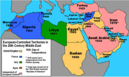
2. colonialism: Most countries in the region were independent of European colonization by the 1950s but the legacy remained.
a. French: Algeria, Tunisia, Morocco, Syria and Lebanon
b. British: Kuwait, Bahrain, Qatar, United Arab Emirates, Aden (Yemen), Egypt, Sudan, South Sudan, Saudi Arabia and Iraq
c. Italy: Libya
d. Spain: Morocco
e. Persia (Iran) and Turkey were never directly colonized.
3. The global economy is having an impact on traditional cultural values in North Africa and Southwest Asia. Islamic nations have responded negatively to globalization. Nowhere else is violence more often used in the anti-globalization struggle. There are several reasons for this.
a. There is a lack of previous cultural penetration of Islamic nations by Western culture, ideas and institutions. No matter how much such influence can be found it is relatively far less than in other parts of the world. The basic elements of globalization are seen as more alien in this region than elsewhere and are thus far more likely to be seen as hostile.
b. Nationalism comes dramatically into play when certain aspects of
Westernization are seen as challenges to a nation's ethos. The existence of a
large and culturally powerful Arabic community acts as a wall against the
penetration of Western culture which is such an important aspect of
globalization.
c. In this region there exists a fully developed alternative world view that includes both Arab nationalism and Islam as prime ingredients. Globalization is seen as surrender to a dominant, non-indigenous viewpoint. Not only does this lie in contradiction to the prevailing system, but it threatens to undermine it. Rather than adapting to the world, the world is supposed to adjust to Islamic beliefs.
d. Arab nationalists, Islamists and the varying blends of the two, believe they are destined to emerge as dominant in the world, and certainly in the region. Yet they have a profound inferiority complex, a sense of being behind which makes them feel all the more vulnerable. Precisely because they suspect that the emerging global system might be superior to theirs, in its practical effects at least, they fear any compromise will bring total absorption and doubt their ability to survive a cultural synthesis.
e. Authoritarian governments in North Africa and Southwest Asia have learned how to survive and mobilize mass support. While repression is one way they do so, equally or more important are such tools as demagoguery, the creation of a supportive and pervasive system, the persuasion of the public to support their governments, the claim that anti-globalization is the only way of defending the Arab nation and Islam, and the use of anti-American and anti-Israel sentiments. By presenting change as dangerous and compromise as surrender, the regimes keep the support of their own people while also discouraging them from supporting certain elements of globalization -- such as democracy, free enterprise, civil and human rights -- which would increase opposition to current regimes or even lead to their demise.
f. Many elements of globalization can contradict – or be thought to conflict with – Islam. Where religion is more traditional in its practice, the defense of religion also conflicts with the acceptance of modernization.
g. Globalization is only accepted if and when it is perceived not as destroying a local society but as helping it to survive and flourish in a partly new form. Keep in mind, though, that even the most extreme explicit rejection of globalization does not mean that globalization fails completely to infiltrate a society.
4. North Africa and Southwest Asia is a region of conflict. Conflict between Israel and one or more of the Arab nations has existed since Israel’s establishment in 1948 but Arab vs. Israel is not the only conflict. Conflict between Arab nations is not uncommon – Iraq-Kuwait, Iran-Iraq, etc. Conflict within Arab nations is becoming the norm – Iran, Iraq, Libya, Sudan, Syria, Yemen, etc. These conflicts are often (but not always) cultural in nature. Please look at the Optional Resources section below for specifics of conflict in any of these countries.
 Demographic Characteristics
1. physiological density: the number of people relative to the amount of farmable land, a basic indicator of a country's food-producing capability and the human pressure placed on it … Arable land is defined as all land cultivated for crops that are replanted after each harvest, which excludes land in permanent crops that are not replanted after harvesting (rubber, citrus, coffee). Physiological densities in the region are among the highest on earth. They range from a regional low of 650 (Sudan) to a high of 222,200 (Bahrain).
2. one of the world’s earliest hearths of domestication: plant (barley, wheat, rice, lentils, peas, chickpeas, bitter vetch, flax) and animals (cattle, camel, sheep, goats, horses, dogs, pigs) purposely selected and bred for their desirable characteristics
3. pastoral nomadism: traditional form of subsistence agriculture in which practitioners depend on the regular and systematic seasonal movement of livestock (rather than crops) for a large part of their livelihood … Throughout the Sahara, small groups of people (the most well-known are the Tuareg and the Berbers) adopted a nomadic lifestyle to adapt to the harsh environment. The animals provide milk, and their skins and hair are used for clothing and tents. Their animals are usually not slaughtered, although some dead ones may be eaten. To nomads, the size of their herd is an important measure of power and prestige and also their main security during adverse environmental conditions. The camel is the most highly desired animal in North Africa and Southwest Asia, along with sheep and goats. The typical nomadic family needs 25 to 60 goats or sheep or 10 to 25 camels.
4. oasis life: Desert areas are home to many oases (isolated areas of vegetation in a desert, typically surrounding springs or similar water sources, such as ponds or small lakes) and wadi (dry streambeds/ravines that fill during the rainy season causing flash floods and dangerous mud flows). Oases are formed from underground rivers or aquifers where water can reach the surface naturally by pressure or by man-made wells diligently maintained for generations. The most important plant in an oasis is the date palm, which forms an upper layer under which smaller trees and vegetable crops can be grown.. Oases provide habitats for animals and even humans if the area is big enough. They may also serve as trading centers and larger oases can support small agricultural settlements. The location of oases has been of critical importance for trade and transportation routes in desert areas. Caravans must travel via oases so that supplies of water and food can be replenished. Thus, political or military control of an oasis has in many cases meant control of trade on a particular route. Some of the world's largest supplies of underground water exist beneath the Sahara Desert, supporting about 90 major oases there. However, traveling between Saharan oases can take days because the desert is so vast.


5. Some of the world’s oldest urban areas are in this region. Original settlements evolved into trade centers and then centers of Islamic religious administration and education. The original urban core of a traditional Islamic city is called a medina (walled urban core, dominated by a central mosque and its associated religious, educational and administrative functions). It generally includes the central mosque, a bazaar (sug) and twisting streets to maximize shade. European colonialism, economic growth, oil wealth and migrants have all added additional layers to the region’s traditional urban form.
6. Population is unevenly distributed due to the environment. Population
clusters are found around water sources and are widely scattered.
7. managing water: Water-related issues are of constant concern to most
residents of this region. Freshwater is a valuable commodity, often in short
supply. In some areas, such as in Iran, qanat systems have been modifying
drainage patterns and water flows for thousands of years, enabling better use of
existing freshwater supplies. Other areas are less
 fortunate with reliable
freshwater sources, prompting several governments to invest heavily in
desalinization programs that turn salt water into usable freshwater (an
expensive process that uses water from the ocean, and thus perhaps will create new
problems). In Egypt, the Aswan High Dam on the Nile River, completed in 1970,
has greatly increased storage capacity in the upstream reservoir promoting more
year-round cropping and an expansion of cultivated lands. The chief problem
associated with the use of groundwater is that it is being depleted faster than
replenished. Groundwater is the water found underground – at varying depths – in
the cracks and spaces in soil, sand and rock. It is stored in and moves slowly
through geologic formations of soil, sand and rocks called aquifers. An aquifer
may hold a very large amount of water but that amount is finite and, if used too
much and too quickly, the water can be exhausted. One potential example of this
problem is Libya. Read
Libya’s Fossil Water.
fortunate with reliable
freshwater sources, prompting several governments to invest heavily in
desalinization programs that turn salt water into usable freshwater (an
expensive process that uses water from the ocean, and thus perhaps will create new
problems). In Egypt, the Aswan High Dam on the Nile River, completed in 1970,
has greatly increased storage capacity in the upstream reservoir promoting more
year-round cropping and an expansion of cultivated lands. The chief problem
associated with the use of groundwater is that it is being depleted faster than
replenished. Groundwater is the water found underground – at varying depths – in
the cracks and spaces in soil, sand and rock. It is stored in and moves slowly
through geologic formations of soil, sand and rocks called aquifers. An aquifer
may hold a very large amount of water but that amount is finite and, if used too
much and too quickly, the water can be exhausted. One potential example of this
problem is Libya. Read
Libya’s Fossil Water.

The Persians, from modern-day Iran, devised an innovative way to transport water known as a qanat. Qanats are underground tunnels used to extract groundwater from below mountains and transport it downhill, where it is used to irrigate cropland. They were developed over 2,500 years ago and many old qanats are still in use today in Iran as well as Afghanistan.

8. More than 35% of population less than 15
years old, due to conflict, disease and the hardships associated with the
region. When these cohorts reach reproductive age, increasing population will
place a strain on cities and water supplies.
Old World, Young Africa: The world is becoming more African.
9. urbanization: As in many other areas of the world, rapid urbanization is of concern in this region, not only because of the sprawl it often creates, but also the pressure it places on the natural resources of the area. In populated locations such as Riyadh, Saudi Arabia, and the Nile River Delta in Egypt, urbanization has increased dramatically over the past 40 years.
1. The development of North Africa and Southwest Asia has been slowed by
wars over territory and religious differences, and by the lack of resources in
some countries. There is a heavy reliance on primary economic activities such as
oil drilling, agriculture and herding/grazing. Oil is the biggest resource in
this region. It holds around 68% of the world’s petroleum reserves. In addition
to fossil fuels, some minerals are found in abundance: iron ore (steel), copper
(pipes, wiring, computer parts), lead (car batteries, firearms, radiation
shielding), manganese (steel), zinc (deodorant, paint, dandruff shampoo) and
phosphate (fertilizer). Industry and manufacturing are a major part of the
economies of Israel and Turkey because they have little oil and few minerals.
Israel is the most prosperous nation, and with the least amount of resources.
Some of the smaller countries, located along the Persian Gulf, have become very
rich from the exportation of oil.
2. Region has 68% of the world’s proven oil supplies and only 7% of its population.

3. Oil is unevenly distributed but most of the economies in North Africa and Southwest Asia are dominated by the production of petroleum.
4. higher-income oil exporters
Saudi Arabia, Kuwait, Qatar, Bahrain, UAE
Cultural landscape reshaped because of oil wealth.
not all benefit: rural Shiite Muslims and foreign workers
5. lower-income oil exporters
Algeria, Libya, Iraq, Iran
Individual circumstances have stifled economic growth.
political hostility, sanctions, limits on international trade
6.
OPEC can no longer control
oil prices globally but it still influences price and availability.
7. Fertile Crescent: Historically, this area of very rich soil formed an arc or crescent shaped parcel of land stretching from the Persian Gulf to the Mediterranean Sea. Some experts also include the fertile lands of the Nile River Delta in the Fertile Crescent. The Tigris and Euphrates Rivers flow almost parallel to one another which allows the flood plains of each river to join together, thus providing thousands of hectares of once rich farmland. This fertile land was the site of ancient Mesopotamia, which means "land between two rivers" (today it is Iraq). The floodplains of the Tigris and Euphrates Rivers then connect with fertile lands located on the eastern coast of the Mediterranean Sea (Israel and Lebanon).

8. Most of the farming in the region is in areas with a Mediterranean climate. The steppe areas are well-suited to raising livestock. More recently, many farmers in North Africa and Southwest Asia chose to grow crops like European and American farmers who use irrigation to water land that does not receive enough precipitation to grow a large amount of plants. Irrigation can increase crop output but it can also have a negative impact on the environment. Most irrigation has come from damming rivers, which can affect how the river flows and create problems along the entire river.
9. great variation in standards of living: ranging from relatively high to poverty stricken … wide range of per capita income and levels of development
10. The region’s location (crossroads of Europe, Africa, Asia) has resulted in global interest throughout history. Trade has been important to the region from the earliest times.
1. Ottoman Empire: vast Islamic empire (included southeastern Europe and most of Southwest Asia and North Africa), replaced the Byzantine Empire as the major power in the Eastern Mediterranean ... one of the largest, longest-lasting (1301-1922) and most successful empires in history
a. highly centralized political structure
b. power always transferred to an individual rather than split between rival princes (Whenever a new Sultan ascended to the throne his brothers were locked up. As soon as the Sultan had produced his first son, his brothers (and their sons) were killed (or sometimes imprisoned for life). The new Sultan's sons would be then confined until their father's death and the whole system would start again.)
c. state-run education system
d. religion incorporated in state structure and Sultan regarded as protector of Islam
e. state-run judicial system
f. ruthless in dealing with local leaders
g. promotion to positions of power largely depended on merit, not family or wealth
h. created alliances across political and racial groups
i. united by Islamic ideology
j. united by Islamic warrior code with goal of increasing Muslim territory through jihad
k. united by Islamic organizational and administrative structures
l. highly pragmatic, taking the best ideas from other cultures and making them their own
m. relied on continuous expansion for stability: did not develop conquered territory but rather exploited it to the point of exhaustion and then more or less abandoned it in favor of new territory ... empire either grew or collapsed
n. encouraged loyalty from other faiths
i. Christians were the largest group of the population and coexistence was likely to be more efficient than one of conflict.
ii. Institutions of the Church provided a machine for implementing empire's rule.
iii. Islamic rule that Muslims should show respect to all religions
o. policy of increasing the number of traders and artisans
p. private power and wealth were controlled
q. Shi'a were ruthlessly suppressed and retreated to Persia.
r. very strong and organized military
i. strong slave-based army
ii. expert in developing gunpowder as a military tool
iii. military ethos pervaded entire administration
 2. The narrow Strait of Hormuz is considered one of the most strategic
straits (narrow strip of water) on the planet. It links the Persian Gulf with
the Arabian Sea and the Gulf of Oman. The Strait of Hormuz is important because
it is a geographic chokepoint (a narrow channel used as a sea route for the shipment of
goods) and through its waters passes much of the oil from Southwest Asia.
Bordered by Iran, Oman's Musandam Peninsula and the United Arab Emirates, this
stretch of water is of obvious military significance, and subsequently, the US
Navy and others patrol its waters year round. Due to its importance, Iran (who
shares territorial rights over the straight with Oman) has threatened to close
the straight several times in recent history and it has been the center of
conflict numerous times. In the past, the US has responded to threats of closure
by claiming that any closure of the strait would be treated as an act of war.
What is the Strait of Hormuz? Can Iran shut off access to oil?
2. The narrow Strait of Hormuz is considered one of the most strategic
straits (narrow strip of water) on the planet. It links the Persian Gulf with
the Arabian Sea and the Gulf of Oman. The Strait of Hormuz is important because
it is a geographic chokepoint (a narrow channel used as a sea route for the shipment of
goods) and through its waters passes much of the oil from Southwest Asia.
Bordered by Iran, Oman's Musandam Peninsula and the United Arab Emirates, this
stretch of water is of obvious military significance, and subsequently, the US
Navy and others patrol its waters year round. Due to its importance, Iran (who
shares territorial rights over the straight with Oman) has threatened to close
the straight several times in recent history and it has been the center of
conflict numerous times. In the past, the US has responded to threats of closure
by claiming that any closure of the strait would be treated as an act of war.
What is the Strait of Hormuz? Can Iran shut off access to oil?
3. theocratic state: one in which religious leaders (ayatollahs) guide policy
4. politics of fundamentalism
Originated in Iran, 1978–1979, when Shiite clerics (Khomeni) overthrew Shah.
Sudanese fundamentalists overthrew democracy in 1989, Algerian in 1992, and Afghan in 1994.
strong undercurrent in most countries in the region
5. conflicts within states
Lebanon: conflict among Sunni and Shiite Muslims and Christians, due to spread of Palestinian refugees in region
Iraq: borders drawn by outsiders, Persian Gulf War in early 1990s
Cyprus: conflict between Greece and Turkey, Green Line (demarcation set up by UN peacekeepers that divides the capital of Nicosia in Cyprus)
6. conflicts between states
Libya and world: finances terrorism, water usage, intermittent military aggression against neighbors (Note: all occurred under Kaddafi, whose death leaves future uncertain)
Iran and Iraq: Shi'ite vs Sunni conflict (deadly serious schism within much of Muslim world)
Since the 1979 takeover of Iran by Ayatollah Ruhollah Khomeini, the country’s Islamic revolutionary government has had one overriding ambition: to be the lead player shaping the future of the Middle East. Seen another way, it wants Israel weaker and the US gone from the region after decades of primacy. Iran sees existential threats everywhere and seeks to counter them. Iran, which has a Shiite majority, has wary, if not hostile, Sunni Arab neighbors. Its archenemy, Israel, has the reach to damage Iran. And since 2003, Iran has been surrounded by US troops in Afghanistan, Iraq, the Persian Gulf and Syria. To achieve regional hegemony and safeguard its theocracy, Iran has responded on three fronts: military, diplomatic and economic.
Militarily, Iran’s government wants to project strength without drawing fire on its own territory, which could jeopardize its already tenuous popular support. Its strategy has been to build up regional proxy forces so that it rarely launches attacks from its own soil. The Axis of Resistance is the network of Iran-backed groups across the Middle East dedicated to reducing US influence in the region and ultimately eliminating the state of Israel. Israel is the region’s only nuclear-armed power. But in the past year, Tehran has accelerated its uranium enrichment efforts, bringing it close to creating a nuclear bomb if it wants. The Axis includes Hamas, Hezbollah, the Houthis and other groups, and both its strategy and its tactics have long been radical. The official slogan of the Houthis - the Yemen-based group that has attacked commercial ships in the Red Sea - includes “death to America, death to Israel, a curse upon the Jews,” for example. Even though Iran funds and supports the Axis (Hamas, Hezbollah and the Houthis could not exist as they do without the money and weapons they receive from Iran.), other countries have often treated its member groups as distinct from Iran. Attacks by Hamas or Hezbollah usually did not lead to reprisals against Iran. The events of 2024 threaten to change this dynamic.
Iran’s foreign policy is designed to try to reverse its image as an isolated nation. It has been cultivating its Arab neighbors as well as Russia and China. Iran is a vocal defender of the Palestinian national cause. It believes it draws legitimacy from the contrast with its neighbors, many of which have opened friendlier relations with Israel while Iran’s proxies are still fighting it.
Economically, Iran has had far more limited success, with many Iranians poorer and more resentful of the government. Still, Iran has found ways to take advantage of a rising tide of anti-US feeling among many countries. Tehran joined the Shanghai Cooperation Organization, which is led by Russia and China, and another partnership that includes Brazil and India. These deals open the door to investment and trade opportunities, although they supply few short-term economic solutions. Iran is a major winner from the 2023-2024 conflict in the Middle East. The war is in many ways boosting Iranians’ domestic, regional and global situation. Iran has been able to gain benefits without paying direct costs.
Iran Is the Common Link in Conflicts From Gaza to Pakistan
Turks and Kurds: Kurds make up a cohesive nation who want their own state and have taken a separatist stand for years. About half live in Turkey and a Kurdish state would greatly alter Turkey's physical area, potential resources and regional relationships.
The West Bank and Gaza, which are known as the Palestinian territories, as well as East Jerusalem and Israel all formed part of a land known as Palestine from Roman times until the mid-20th century. These were also the lands of Jewish kingdoms in the Bible, and are seen by many Jews as their ancient homeland. Israel was declared a state in 1948, though the land is still referred to as Palestine by those who do not recognize Israel's right to exist. Palestinians also use the name Palestine as an umbrella term for the West Bank, Gaza and East Jerusalem. Hamas is the Palestinian Islamic militant group that controls the Gaza Strip. Hamas has fought several wars with Israel since it took power. Its political leader is Ismail Haniyeh. Israel had considered Hamas a terrorist organization, but one that could help govern Gaza.
 The
Qassam Brigades is the armed wing of Hamas.
Muhammed Deif, whose real name is Mohammed al-Masri and who is known as The
Guest, became the leader of Hamas’s military wing in the early 2000s. He has
transformed Qassam from an insurgent militia into a capable fighting force. His
influence over the wider Hamas political movement is unclear. Hamas has what the
Israeli military call the
Hamas metro system, an underground network of defensive tunnels that
extend south into Egypt and that militants are said to use to travel undetected
and to move rockets and other munitions. The Israeli military has described the
network as a “city beneath the city,” much of it under the civilian
infrastructure. The tunnels are also meant to complicate any Israeli ground
invasion. Israel has constructed an underground barrier with sensors to detect
tunnels crossing into its territory. Inside Gaza, the underground network has
remained one of Hamas’ main strategic assets. The tunnels run for hundreds of
miles, are as deep as 66 feet and are made of reinforced concrete. Parts of the
tunnels are large enough for vehicles to drive in them. Hamas has laid booby
traps and improvised explosive devices (IEDs) at entry points and along narrow
streets. Egypt’s government also views the tunnels as a security threat. A
decade ago, Egypt tried to destroy some tunnels along its border with Gaza, by
dumping sewage into them and leveling houses that concealed entrances.
The
Qassam Brigades is the armed wing of Hamas.
Muhammed Deif, whose real name is Mohammed al-Masri and who is known as The
Guest, became the leader of Hamas’s military wing in the early 2000s. He has
transformed Qassam from an insurgent militia into a capable fighting force. His
influence over the wider Hamas political movement is unclear. Hamas has what the
Israeli military call the
Hamas metro system, an underground network of defensive tunnels that
extend south into Egypt and that militants are said to use to travel undetected
and to move rockets and other munitions. The Israeli military has described the
network as a “city beneath the city,” much of it under the civilian
infrastructure. The tunnels are also meant to complicate any Israeli ground
invasion. Israel has constructed an underground barrier with sensors to detect
tunnels crossing into its territory. Inside Gaza, the underground network has
remained one of Hamas’ main strategic assets. The tunnels run for hundreds of
miles, are as deep as 66 feet and are made of reinforced concrete. Parts of the
tunnels are large enough for vehicles to drive in them. Hamas has laid booby
traps and improvised explosive devices (IEDs) at entry points and along narrow
streets. Egypt’s government also views the tunnels as a security threat. A
decade ago, Egypt tried to destroy some tunnels along its border with Gaza, by
dumping sewage into them and leveling houses that concealed entrances.
How the subterranean maze of tunnels below the Gaza Strip works.
Egypt and other Arab governments have no love for Hamas and often quietly share
intelligence with Israel. Leaders from Saudi
Arabia, Jordan and Egypt fear the war could destabilize their countries. Western nations consider Hamas a terrorist
organization and the brutality of its 2023 attacks stripped away any
illusions about the group. In retrospect, some believe the Israelis made
erroneous assumptions about the nature of the threat from Hamas.
Israel has long been caught between its desire
to rid itself of Hamas - which is backed by Iran and openly committed to
Israel’s destruction - and the reality that removing it from Gaza could require
a long war and potentially cost many lives. While Hamas was treated as a
terrorist organization, there were decisions made by Israel to make life easier
for Gazans. Israel completely removed its own
civilian presence in Gaza in 2005 because officials thought Israeli rule of the
territory wasn’t sustainable. (The Coordinator of Government Activities
in the Territories is the Israeli government agency that coordinates civilian
affairs with the Palestinian authorities.) In 2006,
Hamas won parliamentary elections. In 2007, the group violently took control of
the Gaza Strip from the internationally recognized Palestinian Authority, which
still governs most Palestinians in the occupied West Bank. Israel and Egypt
quickly placed a tight blockade on the territory.
Israel sought to provide economic benefits to residents of Gaza in order to raise the cost of direct conflict for Hamas. Israel loosened trade restrictions on the blockaded enclave, which is home to two million people, and bolstered supplies of water, medicine and fuel. It allowed Qatar to begin sending millions of dollars to the Hamas government to boost the economic incentives for the militant group to maintain peace. It issued 15,000 work permits, for workers in Gaza who came into Israel each day, and there was a view that Hamas would not screw that up. But Hamas and other groups are sworn to Israel's destruction and want to replace it with an Islamic state. Hamas’s leaders say the group attacked Israel on October 7, 2023 because they believed the Palestinian cause was slipping away. “We succeeded in putting the Palestinian issue back on the table,” one leader said.
Who benefits from the conflict? Iran does because it pushes a wedge between Israel and the Saudis, and Iran wants to derail the emerging peace between Saudi Arabia and Israel. Officers of Iran’s Islamic Revolutionary Guard Corps (IRGC) had worked with Hamas since August. Details of the Hamas operation were refined during several meetings in Beirut attended by IRGC officers and representatives of four Iran-backed militant groups, including Hamas and Hezbollah, the Lebanese Shiite militant organization committed to the destruction of the Jewish state and a close ally of Iran. Almost all Hamas rockets and missiles are Iranian-designed weapons that are smuggled into Gaza as components, via underground and sea routes and through legal crossings, then assembled covertly. The IRGC gave the final go-ahead the prior Monday in Beirut, according to senior members of Hamas and Hezbollah. Hamas has publicly acknowledged receiving support from Iran but Iran has refused to take credit for any involvement. A direct Iranian role would take Tehran’s long-running conflict with Israel out of the shadows, raising the risk of broader conflict in the Middle East. The IRGC’s broader plan is to create a multi-front threat that can strangle Israel from all sides - Hezbollah and the Popular Front for the Liberation of Palestine in the north and Palestinian Islamic Jihad and Hamas in Gaza and the West Bank. Leading the effort to wrangle Iran’s foreign proxies under a unified command has been Esmail Qaani, the leader of the IRGC’s international military arm, the Quds Force. Iran has been setting aside other regional conflicts, such as its open feud with Saudi Arabia in Yemen, to devote the IRGC’s foreign resources toward coordinating, financing and arming militias antagonistic to Israel.
Given the combined resources of the Shin Bet (Israeli domestic security services), its external spy agency Mossad, and all the assets of the Israel Defense Forces, it is astounding that nobody saw this coming or failed to act on it if they did have warning. Israel has arguably the most extensive and well-funded intelligence services in the Middle East, with informants and agents inside Palestinian militant groups, as well as in Lebanon, Syria and elsewhere. The border fence between Gaza and Israel has cameras, ground-motion sensors and regular army patrols. The barbed-wire topped fence is supposed to have been a "smart barrier" to prevent exactly the sort of infiltration that took place in the attack. But Hamas militants simply bulldozed their way through it, cut holes in the wire or entered Israel from the sea and by paraglider.
Israel sought to contain Hamas for years. Now it faces a potentially costly fight to eliminate it. Mass displacement of civilians and extensive loss of Palestinian life could erode international support for Israel. And even if Israel is successful in eliminating Hamas, it isn’t clear that it could govern the enclave.

7. politics of water: Water is a critical resource and the lack, especially coupled with the misuse, of water creates the potential for conflict in the region.
a. The ongoing civil war in Yemen has affected that country’s water situation with various reports stating the capital Sana’a will run out of water as soon as 2017. Only 40% of the households in the city are connected to the municipal water supply and they get water maybe twice a week. The country doesn’t harvest rainwater, relying instead on dwindling groundwater supplies.
b. Around 90% of Libya is desert and the groundwater recharge rate is one-fourth the rate of consumption. The country has also expanded agricultural activity by planting water intensive crops and is not reusing its treated wastewater properly.
c. The cost of water in Jordan has gone up 30% in the last decade due to a shortage of groundwater. Jordan is the third driest country in the world and much of the country’s water network is aging. They have no water resources other than underground aquifers. The influx of Syrian refugees in the country has worsened the situation.
d. An increasing population and falling groundwater levels are the main cause of Oman’s water problems. The country has several desalination plants that supply 80% of the potable water but they are failing to meet the rising demand.
e. The United Arab Emirates has the highest per capita consumption of water in the world. Some estimate that they will completely run out of natural freshwater in the next 50 years. Relying on desalinated water, treated waste water and ground water, it’s one of the least water secure countries. They are now investing in cloud seeding technology to increase the rainfall in the country.
f. With one of the world’s lowest levels of rainfall, Qatar faces the immense challenge of looking for an alternative source of freshwater. Their per capita use of water is twice the average consumption in the European Union and their population is expected to grow eightfold by 2050.
g. Go to North Africa and Southwest Asia, scroll a little way down the page and read the Access to Fresh Water section (through Water Shortages in Arabia).
8. Arab Spring of 2011 (Please scroll down to and read the Arab Spring section.)
9. I2U2 is a grouping of India, Israel, the UAE and the US that is centered on security cooperation and has been described as a Middle East Quad. I2U2 was formed in 2021 to deepen technological and private sector collaboration in the region and tackle transnational challenges in six focus areas: water, energy, transportation, space, health and food security. The partnership is based on cooperation and not on competition, and thus serves as a regional platform and model to deepen economic integration with the Middle East, Asia and beyond. Largely missing, however, is any overarching, principled vision of what unites these four states in partnership. Indonesia, Japan and South Korea have been cited as potential Asian partners and the United Kingdom as a potential European partner with strong ties to the states already involved.

10. North Africa and Southwest Asia
a. People’s Democratic Republic of Algeria
g. Hashemite Kingdom of Jordan
j. Libya
m. Palestinian Territories: Gaza Strip and West Bank (Israel)
t. Republic of Turkey (Turkiye)
u. United Arab Emirates (UAE)
v. Western Sahara (or Sahrawi Arab Democratic Republic, Morocco)

Political Resources on the Net
Google's Arts & Culture collection virtual world museum tours
Ottoman Empire Links: The Ottomans is an information portal for Ottoman history, military, culture and arts. | The Ottoman Empire Resources | Ottomans Art Blog
From silk to oil: Cross-cultural connections along the Silk Road
The Organization of Petroleum Exporting Countries (OPEC) is an intergovernmental organization dedicated to the stability and prosperity of the petroleum market, as enshrined in the OPEC Statute. It has eleven members. An organization like OPEC is also known as a cartel because it regulates prices and output.
Tackling the global refugee crisis: From shirking to sharing responsibility
Finding the balance: Population and water scarcity
Inside the Mosque: What do you need to know?
Behind stark political divisions, a more complex map of Sunnis and Shiites
The Rise and Spread of Islamic State (PDF)
Algeria | Economy | Algeria: Current Issues | Culture | Inked Heritage: Berber women's tattoos In Algeria | Photos | Algeria from a drone might be the most stunning place we've ever seen. | Sacred Sites of Algeria | The three internet devices that shook up Algeria's election | Algeria's birth of a new democracy | Human Rights Watch: Algeria | Forecast
Bahrain | Government | Arab Spring: Bahrain | Bahrain: The revolution that wasn't | Was Bahrain's uprising worth it? | Meet Bahrain’s awful judges | Bahrain court upholds dissolution of main Shiite opposition group. | Bahrain's truth will out. | Bahrain's money talk | Economy | Culture | Photos | News of Bahrain | Forecast
Egypt | Arab Spring: Egypt | Sacred Sites of Egypt | Forecast
Inaugurated in 1876, the Suez Canal joins the Mediterranean and the Red Sea and is the longest canal without locks in the world. | See the Suez Canal and the Nile Delta from the Space Shuttle. | Time Lapse video of the Suez Canal North Bound from the Great Bitter Lake to the Med
Take a trip down the Nile River, from Lake Nasser to Cairo, and view
life on the shores of this important waterway. See the Great Sphinx and tour
the Valley of the Kings.
Great Pyramids of Giza in Egypt: An Arabian proverb says, "Everything in the world is afraid of time, and time is afraid of the pyramids."
Iran | Is Iran Dangerous -- or Desperate? Both | A journey through Iran: Eye-opening photographs reveal an enchanting, mysterious and rarely seen side of the country | Execution looms for Iranian child bride | Persia: Ancient Soul of Iran | Photos | Forecast | US-Iran relations: A brief guide | Borderless Blogger: Notes on a Journey through Lārestān, Iran | Two16-year-old girls were killed by the Iranian security services in a crackdown on the protests that have rocked the country. (10/13/22) | A viral dance and ‘happiness campaign’ (that started when a 70-year-old fish market stall owner nicknamed Booghy was grooving in public in violation of Iranian law) frustrates Iran’s clerics. You will absolutely love the videos!
Iraq | How to Recover From Genocide? What Iraq Can Learn from Rwanda | Inside ISIS | ***Islamic State (formerly ISIS, ISIL) group: The full story (an essential resource) | Iraqi Kurdistan profile | Forecast | Islamic State and the crisis in Iraq and Syria in maps | Iraq has a long history of people using the environment as a tool of war. | Recognition for Iraqi Kurdistan and Somaliland | Every year, millions of pilgrims descend on the central Iraqi city of Karbala to commemorate the Shiite religious holiday of Arbaeen. Take a tour of the festivities in 2019.
Journey to Iraqi Kurdistan: Realm of the Endangered Yazidi Pagans and Female Anti-ISIS Peshmerga Fighters | The Kurds and Kurdistan (PDF)
Jerusalem, Israel is one of the oldest cities on our planet. It was first mentioned in the 19th - 13th centuries BCE. The Kingdom of Judah, the empire of Alexander the Great, Syria of Seleucids, Ptolemaic Egypt, Ancient Rome, Byzantium, the Arab Caliphate, the Crusaders, the Ayyubid dynasty, the Mongol-Tatars, the Mamluk Sultanate, the Ottoman Empire, the British Empire, Jordan and Israel all ruled Jerusalem at one time or another. The Old City is the heart of modern-day Jerusalem. The narrow cobbled streets, majestic walls, Roman columns and ancient buildings hold memories of numerous legendary events. The Old City is home to shrines of three of the world's major religions: Judaism, Christianity and Islam.
Israel | Israel’s forgotten tribe | A city where Heaven and Earth meet | Myths and Facts: A guide to the Arab-Israeli conflict (The link is to one section only … the entire document is available here.) | Secular Jews rediscover Jewish heritage. | ***Primer on Palestine, Israel and the Arab-Israeli Conflict (an essential resource) | The Times of Israel | The Jerusalem Post | Forecast | Holy Land | The 11 biggest myths about Israel-Palestine | Jerusalem Israel Cam | ‘Wounds Will Need to Be Healed’: Collisions in a Fractured Israel
Jerusalem is one of the most interesting cities in the Middle East, with
a rich history dating back some 3,000 years before the time of Jesus Christ.
Jordan | Geography | The Country and People of Jordan | Photos | Economy | Culture | King Hussein bin Talal | The Hashemites | Jordan’s King Abdullah swears in new government headed by PM Mulki. | Freedom House: Jordan | King of Jordan discusses threats to Jordan, Western ignorance on CBS’ 60 Minutes. | Jordan's king thrusts country to center of Islamic State war. | Discrimination against Women | Human Rights Watch: Jordan | Forecast | Amman Jordan Cam
 Travel to Kuwait and visit the country that was the focus of the 1991
Persian Gulf War between the US and Iraq. |
Sectarianism and Authoritarianism in Kuwait |
Kuwait |
Forecast
Travel to Kuwait and visit the country that was the focus of the 1991
Persian Gulf War between the US and Iraq. |
Sectarianism and Authoritarianism in Kuwait |
Kuwait |
Forecast
Lebanon | Geography | History and photos | Photos 2 | Photos 3 | Culture | The Country and People of Lebanon | The Beautiful Country of Lebanon | Economy | Freedom House: Lebanon | Human Rights Watch: Lebanon | ISIL claims responsibility in deadliest attack in Beirut since end of civil war kills dozens. | Hezbollah leader Nasrallah says Wahhabism is worse than Zionism. | The Daily Star | Forecast
Libya | History and Geography | Photos | Photos 2 (Use culture, slideshow, faces, Tripoli and Benghazi links … try other links, too, if you want.) | How the Kaddafis lived | Arab Spring: Libya | Libya: Chronology of conflict | ISIS rises in Libya. | Britain's Libya intervention led to growth of ISIS, inquiry finds. | Libya, US face entrenched Islamic state. | UN calls for support for Libya government, upholding of ban on arms. | Libya's central bank causing 'civil war' by paying rival militias, says UK envoy. | UN Libya envoy warns against descent into chaos. | The Middle East might just be a problem that can't be solved – least of all by Arab dictators. | Human Rights Watch: Libya | Libya Herald | Climate change significant challenge facing Libya | Forecast
The biggest city in Morocco is not the capital city of Rabat. It is the ancient legendary city of Casablanca. Casablanca is also the largest Atlantic port of the country, one of the most influential trade centers in North Africa and an important industrial and financial center. The most famous landmark of Casablanca is undoubtedly the Hassan II Mosque (or Grande Mosquée Hassan II). This is the second largest mosque in the world after the Sacred Mosque in the city of Mecca. The Hassan II Mosque was built on the Atlantic shore with a spectacular ocean view that can be seen from the giant glass prayer hall that can host up to twenty-five thousand worshipers. Another eighty thousand people can use the grounds outside the mosque. The total area of the Hassan II Mosque is over 22 acres; the height of the minaret is 689 feet, which makes it the tallest religious structure in the world. Half of the Hassan II Mosque territory is located above the water of the Atlantic Ocean. According to the architect, he was inspired by the verse from the Koran, “Allah's throne is on the water.” He created the mosque in such a way that during high tide, praying people have the illusion of floating on top of the water; the higher the waves, the stronger the illusion. | Sacred Sites of Morocco | The stories – and secrets – of Fez | The secret powers of Sufi sounds (3:53) | Volubilis: Ancient Settlement in Morocco | Forecast | A secret town drenched in blue
Take a photographic tour of Morocco and experience day-to-day life in this northwest African nation.
Take a photographic tour of Oman and experience day-to-day life in this central Asian nation. | Oman | Oman’s Musandam Peninsula | Forecast
Palestinian Territories
|
Interactive map: The West Bank and The Gaza Strip
| ***What's
the difference between the West Bank and the Gaza Strip? (an essential
resource) |
West Bank History
|
Walls in the desert: Are they worthy of our faith?
|
Israel quietly legalizes pirate outposts in the West Bank. |
Hezbollah terror cells, set up via Facebook in West Bank and Israel.
|
Israel and the West Bank through fresh eyes |
Gaza Strip History
|
Everything you need to know about the Israel-Gaza conflict |
Life in the Gaza Strip
|
The Tunnels of Gaza
|
Gaza's tunnels, now used to attack Israel, began as economic lifelines.
| Hamas grows with young
recruits eager to fight Israelis. |
Gaza could be 'uninhabitable' by 2020 if trends continue, says UN.
|
Forecast |
A photographer went on a Gaza airdrop. Here’s what he saw.
|
A photographer went on a Gaza airdrop. Here’s what he saw.
Qatar | History and Geography | Qatar.com | Economy | The Emir of Qatar who transformed his country: Sheikh Hamad bin Khalifa | US approves Boeing, Lockheed fighter jet sales to Gulf. | Qatar University | Culture | Qatari Architecture | The World Almanac of Islamism: Qatar | The case against Qatar | Qatar 'using forced labor' at 2022 World Cup Stadium. | Human Rights Watch: Qatar | Qatar News Agency | Gulf Times | Forecast
Saudi Arabia Ministry of Information has an extensive site containing information released by the Saudi Arabia Ministry of Information, and containing a broad range of topics, from tourism to history to current events. The pages on Islam are interesting and provide good insight into concerns of the region. Similarly, the Issues section has good information on many topics brought out in the text, such as cultural nationalism and globalization. | Saudi Arabia | What to do about Saudi Arabia | Hezbollah leader Nasrallah says Wahhabism is worse than Zionism. | Kingdom on the Edge: Saudi Arabia | Forecast

South Sudan | The Dinka people of South Sudan | Conflicts in South Sudan | South Sudan's chaotic slide back into conflict: an insider's view | 'We just want to live.' – on the road with South Sudan's refugees | Confidential UN report details South Sudan threats, violence. | Violence in South Sudan orchestrated by government, UN report reveals. | Tired of war: South Sudan street artists calling for peace - in pictures. | South Sudan rebel chief urges armed resistance to Juba govt. | South Sudan rebel leader says president wants 'ethnic state.' | South Sudanese general paid $1.5m for Melbourne home, says war profiteering report. | South Sudan’s vice president responds to report over misuse of aid. | The world’s newest country is broken and forgotten.
Sudan | Culture | Our Africa: Sudan | African Studies Center: Sudan | Conflicts in Sudan | What’s happening in Sudan? | UN report says Sudan violates Darfur sanctions. | Lost in the Sahel | Human Rights Watch: Sudan | Sacred Sites of Sudan | Sudan Tribune | The Women of Minbar-Shat (PDF) | Ramadan Nights Provide Cherished Pause in a Sudan on the Brink (April 2022)
Syria | Arab Spring: Syria | President Bashar al-Assad | Syria's ruling Baath Party | Alawites: The secretive sect in charge of Syria | Life expectancy in Syria fell by six years at start of civil war. | Syria: Mapping the conflict | Syrian government troops launch ground assault to retake Aleppo. | Aleppo before and after the war – Photos | Aleppo in ruins: a bird's eye view (00:59) | So now we know: Russia is as powerless in Syria as the West. (Look, too, at the Rebel groups in Syria box near the bottom.) | A guide to where the key countries stand | Syria will not become another Libya or Iraq, says Syrian UN envoy. | Five years into war, what is left of the country? | ***Syria: The story of the conflict in 8 steps (an essential resource) | Golan Heights profile | Forecast | Syria Regional Refugee Response | Islamic State and the crisis in Iraq and Syria in maps | Syria: The story of the conflict | How do Syrian children explain the war? (3:32) | Syrian Journey: Choose your own escape route | Confusion About Syria’s Alawites
Tunisia | Geography | Culture | The old town (medina) of Tunis | Sacred Sites of Tunisia | Arab Spring: Tunisia | Why Tunisians are protesting again 5 years after the revolution | Economy | Hundreds protest amnesty law for officials accused of corruption. | Tunisia's new government wins parliamentary approval, eyes austerity. | National Democratic Institute: Tunisia | Human Rights Watch: Tunisia | For the sake of Tunisia, don't escalate the armed conflict in Libya. | The problem with saving Tunisia | Does US have the right tools to help a success story like Tunisia? | Tunisia-ten | Forecast | Tunisian Cave Village Empties Out in Face of Drought and Modernity’s Draw
Turkey |
Istanbul, Turkey, is a wonderful city with a unique history. Its strategic
location has attracted many a marauding army over the centuries. The
Greeks,
Persians,
Romans
 and
Venetians took turns ruling before the Ottomans stormed into town and decided to
stay – physical reminders of their various tenures are found littered across the
city. And the fact that the city straddles two continents wasn't its only draw
card. This was the final stage on the legendary
Silk Road that linked Asia and Europe, and many of the merchants who came
here liked it so much that they, too, decided to stay. In so doing, they endowed
the city with a cultural diversity that it retains to this day. The former
capital of the Roman, Byzantine, Latin and Ottoman Empires, the modern Istanbul
has lost the status of the capital, but it is still the third largest city in
Europe. The
Bosphorus Strait splits the city into the European and the Asian parts. Each
of them has preserved monuments of different epochs and has its unique
atmosphere. In addition to magnificent
mosques, the monuments of the Roman-Byzantine period are of exceptional
interest. The
Hagia Sophia Basilica remained the largest Christian cathedral for more than
a thousand years, with a height of 55.6 meters and a dome diameter of 31 meters,
until the Saint Peter's Cathedral in Rome was built. |
Turkey in crisis: a reminder why US shouldn't constantly meddle abroad |
Forecast |
Turkey’s New Maps Are Reclaiming the Ottoman Empire |
Hagia Sophia: Turkey Turns Iconic Istanbul Museum into Mosque |
An Insider’s Tour of Hagia Sophia|
Take a virtual tour of the fabled
Honey Forest in northeastern Turkey, which is home to the beekeeping
traditions of the Hemshin people. The forest is full of the prized hornbeam
trees that have been used for generations to keep bees. | Turkey is crushing the Kurds.
NATO doesn’t seem to care. (05/26/2022)
|
Inside a massive abandoned town of Disney-esque castles |
In Sanliurfa, the Silk Road meets the Stone Age.
and
Venetians took turns ruling before the Ottomans stormed into town and decided to
stay – physical reminders of their various tenures are found littered across the
city. And the fact that the city straddles two continents wasn't its only draw
card. This was the final stage on the legendary
Silk Road that linked Asia and Europe, and many of the merchants who came
here liked it so much that they, too, decided to stay. In so doing, they endowed
the city with a cultural diversity that it retains to this day. The former
capital of the Roman, Byzantine, Latin and Ottoman Empires, the modern Istanbul
has lost the status of the capital, but it is still the third largest city in
Europe. The
Bosphorus Strait splits the city into the European and the Asian parts. Each
of them has preserved monuments of different epochs and has its unique
atmosphere. In addition to magnificent
mosques, the monuments of the Roman-Byzantine period are of exceptional
interest. The
Hagia Sophia Basilica remained the largest Christian cathedral for more than
a thousand years, with a height of 55.6 meters and a dome diameter of 31 meters,
until the Saint Peter's Cathedral in Rome was built. |
Turkey in crisis: a reminder why US shouldn't constantly meddle abroad |
Forecast |
Turkey’s New Maps Are Reclaiming the Ottoman Empire |
Hagia Sophia: Turkey Turns Iconic Istanbul Museum into Mosque |
An Insider’s Tour of Hagia Sophia|
Take a virtual tour of the fabled
Honey Forest in northeastern Turkey, which is home to the beekeeping
traditions of the Hemshin people. The forest is full of the prized hornbeam
trees that have been used for generations to keep bees. | Turkey is crushing the Kurds.
NATO doesn’t seem to care. (05/26/2022)
|
Inside a massive abandoned town of Disney-esque castles |
In Sanliurfa, the Silk Road meets the Stone Age.
UAE | Tribal traditions in the UAE (3:31) | Gulf News | Forecast | Dubai UAE Cam
Off the coast of the Arabian Peninsula, on an island just a few hundred feet from the UAE mainland, lies the island-city of Abu Dhabi, UAE, surrounded by many other islands that are just a bridge away. Abu Dhabi is the capital of the emirate of Abu Dhabi and the capital of the United Arab Emirates, as well as the political, industrial, commercial and cultural center of the country. The main part of the city life is concentrated on the northern side of the island where several street blocks flow out into the Corniche (2:53), a 5-mile-long picturesque waterfront. The City's waterfront has many gigantic skyscrapers that thrill visitors with their size and architectural forms. One of the most important historic landmarks of Abu Dhabi is Qasr Al Hosn, the first fortress of the Abu Dhabi rulers, which was built in 1793. It served as a primary residence for the emirate government until 1966.
The origins of Dubai, UAE, trace back to the 7th century, but Dubai is best described as the City of the Future. Nowhere else on the planet you will find so many incredible architectural constructions that are ultra-modern and even ahead of the times. The list of Dubai’s ultra-modern attractions is a long one but perhaps the most unique is Dubai’s artificial islands – Palm Islands (a gigantic tree built off the coast of the Persian Gulf) and World Islands, shaped as the Earth's continents. The construction of the world’s largest archipelago, Palm Islands began in Dubai in 2001. Workers used millions of tons of sand and stones to create three palms, which is the most honored and popular tree of the East. One of the islands, the Jumeirah, is surrounded by a crescent which serves as both an Islamic symbol and a breakwater. The island's size is 16 by 16 feet; the total size is comparable to 800 football fields. The island joins the mainland via a 900-foot bridge and the crescent and a palm top are connected with an underwater tunnel. And there is a monorail on the bridge — the first one in the Middle East. Not far from the palms is another artificial archipelago — the World. The islands’ sizes vary from 151 to 893,000 square feet. In short, Dubai is a paradise city, a page from a science fiction book, a true picture of how even the most bizarre and ambitious ideas may be implemented into reality.
 Western Sahara (Sahrawi Arab Democratic Republic)
|
Geography |
Ancient river network discovered buried under Saharan sand.
|
Sahrawi people
|
Desert schools bloom in Sahrawi refugee camps – in pictures.
|
A postcard from Western Sahara
|
Western Sahara and Morocco
|
Western
Sahara Resource Watch
|
UN report accuses Moroccan government of intercepting communications and using
‘unethical tactics’ to influence organization on occupied territory.
|
Western Sahara: Why Africa’s last colony can’t break free
|
40 years of suffering for Sahrawi refugees from Western Sahara
|
Morocco continues occupation of Western Sahara, in defiance of UN.
|
Western Sahara activists feel full force of Moroccan intimidation.
|
Human Rights Watch: Western Sahara
|
Freedom House: Western Sahara
|
The word that reignited the Western Sahara debate
|
What next for Western Sahara?
|
Russia shows interest in Western Sahara. |
Committee of 24 reaffirms its mandate of decolonization of Western Sahara.
|
Morocco deals don't cover Western Sahara, EU lawyer says. |
An Invisible War in Western Sahara |
What’s behind Spain’s about-face on Western Sahara? |
Middle East Eye: Western
Sahara Resources |
The Guardian: Western Sahara
Resources |
Al Jazeera: Western Sahara
Resources
Western Sahara (Sahrawi Arab Democratic Republic)
|
Geography |
Ancient river network discovered buried under Saharan sand.
|
Sahrawi people
|
Desert schools bloom in Sahrawi refugee camps – in pictures.
|
A postcard from Western Sahara
|
Western Sahara and Morocco
|
Western
Sahara Resource Watch
|
UN report accuses Moroccan government of intercepting communications and using
‘unethical tactics’ to influence organization on occupied territory.
|
Western Sahara: Why Africa’s last colony can’t break free
|
40 years of suffering for Sahrawi refugees from Western Sahara
|
Morocco continues occupation of Western Sahara, in defiance of UN.
|
Western Sahara activists feel full force of Moroccan intimidation.
|
Human Rights Watch: Western Sahara
|
Freedom House: Western Sahara
|
The word that reignited the Western Sahara debate
|
What next for Western Sahara?
|
Russia shows interest in Western Sahara. |
Committee of 24 reaffirms its mandate of decolonization of Western Sahara.
|
Morocco deals don't cover Western Sahara, EU lawyer says. |
An Invisible War in Western Sahara |
What’s behind Spain’s about-face on Western Sahara? |
Middle East Eye: Western
Sahara Resources |
The Guardian: Western Sahara
Resources |
Al Jazeera: Western Sahara
Resources
Is Western Sahara a Country? (9:14)
Yemen | Geography | Culture | Arab Spring: Yemen | Yemen's Hidden War | Why did Saudi Arabia intervene in Yemen? | Why Saudi Arabia's Yemen war is not producing victory | Saudis may be using US-supplied white phosphorus in Yemen. | UN condemns US-backed Saudi war in Yemen. | Human Rights Watch: Yemen | Inshallah | Yemen Times | Forecast
There are lots of pictures so it may take a minute for the page to open!
![]()
|
|